Overview
Scottish Woodlands has a dedicated management team that delivers and supports Geographical Information Systems (GIS) based mapping services for our own managers and for external clients.
We have been using digital mapping and data management applications in forestry for over 15 years. The extensive experience developed over that time allows us to offer a wide range of 'fit for purpose' solutions in this technically challenging and dynamic field.
Our primary software platform is ESRI’s ArcGIS, but in order to meet the needs of our clients and managers we also have purpose-built software extensions that help us to deliver a comprehensive management system dedicated to forestry. We call this forest management platform 'ArborIS'.

Mobile GIS
In the office or out in the forest GIS can now be available to anyone at any time. We have professional quality GPS units, Windows, iOS and Android tablets and even mobile smart phones that can display our GIS data.
We use the mobile platforms in the field to view aerial photographs base maps and our own GIS data, to capture new spatial data and as real time location devices.
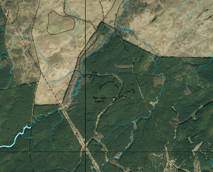
We also have applications that allow us to use referenced pdf’s as a base map so your actual location on the ground can be seen on a pdf or jpeg image, this allows us to share spatial data with external clients and contractors in formats that do not require GIS software.
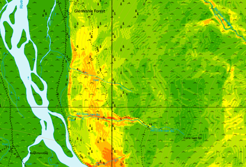
An example of this is used for slope maps:
- We use Digital Terrain Model data and process it in GIS to produce detailed terrain maps
- The data is then exported into a referenced PDF
- This data is shared with contractors or staff for planning or hazard management
- The user’s location is shown 'live' on the map at all times and continuously updated
Hardware and Data Processing
As well as our own internal systems, we have additional experience with a wide range of data formats, software and hardware applications, including but not exclusively;
Hardware
- Drones - for aerial photographs and surface models
- GPS - for location and mapping works
- Laser rangefinders - for height and distance measurements
- Digital Calipers - for tree measurements
- Tablets & mobile phones - for data collection and viewing maps using mobile platforms
Data Processing
- Raster Calculations of LiDAR data for crop height assessments
- DTM & DSM Processing for 3D imagery and slope analysis
- Model building and bespoke programming for data validation and conversion
- Conversion of GIS data into other formats for working outside of GIS, including MS excel, MS access, csv, xml, kmz
- Viewshed analysis
So, if you want to prepare a digital GIS map for your property or you have more complex mapping or data requirements, we will be able to offer solutions. Our forestry and land management experience mean that any solutions we provide incorporate the benefit of this experience and we can resource any field data capture and validation using skilled forestry staff according to your requirements.
We also link and use external datasets from other organisations direct into our GIS.
Examples of data sources include;
SNH, Historic Scotland, Forestry Commission, Scottish Government, Natural England, DEFRA, Natural Resources Wales, Ordnance Survey, SEPA.
This gives us access to hundreds of live data streams direct from source, examples include: Ancient Woodlands, historic monuments, designated areas, aerial photography, land form data, forestry site classification data and grant related information.
Land Registration
In May 2014, the Scottish Ministers instructed the Keeper of the Registers of Scotland (RoS) to complete Scotland’s Land Register within a 10 year period. Since then, Scottish Woodlands have completed a number of plans for the land registration process and are supporting landowners who wish to register their land through the new voluntary process.
The mapping process required by RoS is specific. Our mapping team have experience in the provision of map resources that meet these requirements.
To find out more about Land Registration visit the RoS website.
Contact us
Adrian Kirby
Head of IT & GIS